
A debris basin in Los Angeles County
You may have heard that, after the California wildfires, there’s a scramble to empty “debris basins” there because so many hillsides now lack any vegetation to halt or even slow landslides that will occur on burn-scarred hills after heavy rainfall. The debris basins are man-made bowls of varying sizes, whose construction first began in 1915, meant to catch landslide debris but allow water through. There are more than 120 of them near Los Angeles, where they’re essential because the tectonically active San Gabriel Mountains are both growing and disintegrating at one of the fastest rates on the planet. The basins are regularly emptied by crews, but because of the volume of material, it can be difficult to keep up.
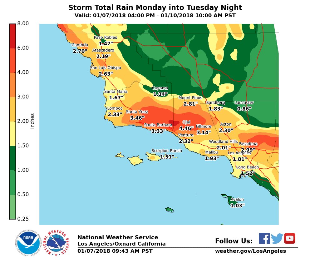
The regional forecast for the next four days is not good: 1-2 inches of rain at the coast and up to 5 inches on west-facing slopes. As little as a quarter-inch of rain in an hour is capable of triggering a landslide in burned areas.
John McPhee wrote about the basins and the underlying geology of the region in The New Yorker in 1988. The second half of his essay is behind their paywall, but the fascinating first half is freely readable here:
Los Angeles against the Mountains, Part 1
Both parts are included in his book, The Control of Nature. When he wrote that essay thirty years ago, the basins had already collected – and been emptied of – over twenty million tons of landslide material. In the eyebrow-lifting words of McPhee:
Some of it is Chevrolet size. Boulders bigger than cars ride long distances in debris flows. Boulders grouped like fish eggs pour downhill in debris flows. The dark material coming toward the [Genofile family] was not only full of boulders; it was so full of automobiles it was like bread dough mixed with raisins.
The lecture notes about McPhee’s essay on this page summarize well the never-ending chaparral overgrowth/wildfire/rain/landslide cycle in Southern California.
The low stuff, at the buckwheat level, is often called soft chaparral. Up in the tough chamise, closer to the lofty timber, is high chaparral, which is also called hard chaparral. High or low—hard, soft, or mixed—all chaparral has in common an always developing, relentlessly intensifying, vital necessity to burst into flame. In a sense, chaparral consumes fire no less than fire consumes chaparral.
As a side note, there’s no need to find blame in campfires of the homeless – or even the far more common cause, poorly-maintained power lines and their rights-of-way – because Southern California wildfires are inevitable. They would, with 100% certainty, occur even if the region was completely uninhabited. It’s not a matter of if – it’s a matter of when.
The strangest aspect of the basins is where much of their debris is transported once removed: back up into the mountains. McPhee called this bizarre flood control district job security an “elegant absurdity”.
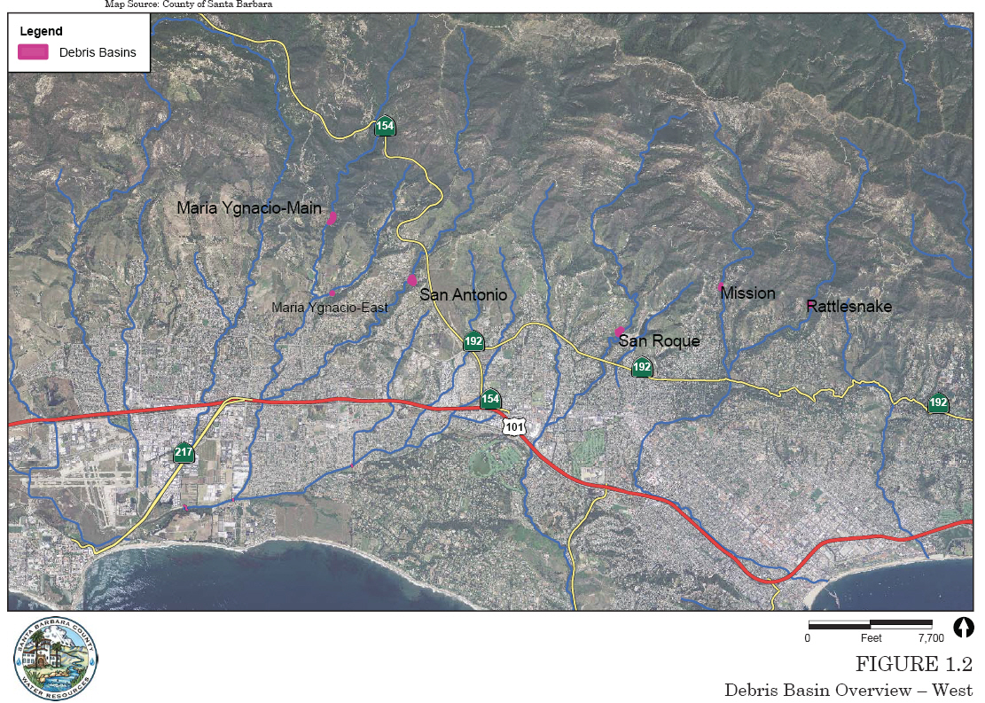
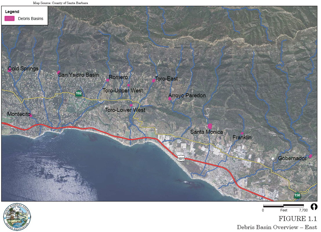
Traveling from the west in the area of the record-breaking Thomas Fire to the east, here are the Santa Barbara County debris basins:
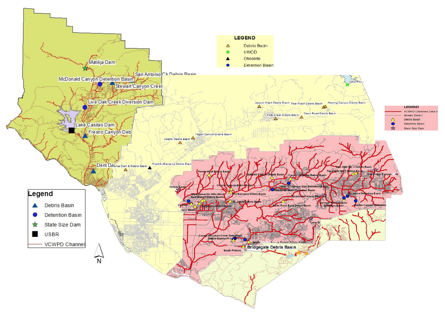
Then Ventura County’s – a little rough looking because I cobbled this together from four zone maps of differing scales:
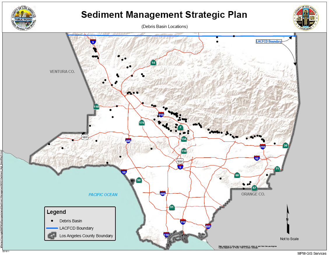
And finally, Los Angeles County’s debris basins, where you can easily see that the landslide problem is most acute:
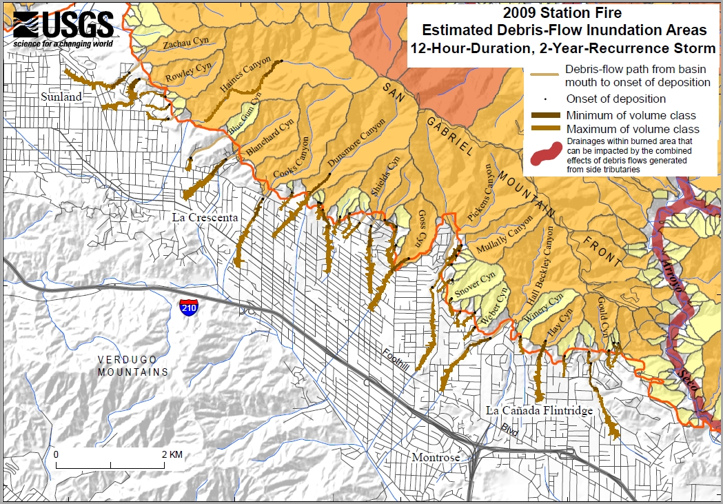
This map of likely landslide paths after the Station Fire in 2009 is an example of just how acute. This area is near the centre of the map above and not far north-northeast of Burbank, Glendale, and Pasadena:

[…] think this and McPhee’s “Los Angeles Against the Mountains” are vital to the proper understanding of wildfires, especially in the western United States. You […]